Real-time weather and snow data in Valemount!

We are happy to report that the first real-time snow station is now up and running in the proposed Valemount Community Ski Hill, as part of the PICS-funded project on mountain geohazarads and snowpacks in the Robson Valley. Two weekends worth of fieldwork (thanks Sami and Mackenzie!) were needed to pour a concrete foundation for the tower, and then to set up the meteorological tower and install the sensors.

The data can be accessed here: https://dashboard.hobolink.com/public/29560/ValemountCSH

Data from the site are updated every hour over the cellular network, and we will be monitoring the battery power closely this winter to see if the battery and solar panel are sufficient for the frequency of data transmission. The station is located at 52.85N, -119.37W, at an elevation of 980 m.


Kickoff Meeting: Community Adaptation to Changing Mountain Snowpacks and Geohazards

Head of the Robson Valley near Valemount, British Columbia.

With ongoing and future climate change, the potential for increased mountain hazards (landslides, mudflows, rockfalls) and reduced mountain snowpacks are a genuinue concern for mountain communities in British Columbia. On June 1-2, MOSH Lab crew and collaborators gathered in stunning Valemount BC to kickoff the PICS-funded project on community adaptation to changing mountain geohazards and snowpacks in the Robson Valley. With Owen Torgerson (Mayor of Valemount) and Dannielle Alan (Regional Director of Fraser-Fort George District H), along with representatives from the Community Forests of Valemount and Dunster and the B.C. Ministry of Forests, the UNBC team had a productive day of meetings, school visits, and a community dinner to discuss the project.

The team, posing for a truck-bumper photo.

MOSH Lab PhD students Sami Sofizada and Sara Darychuk introduced their research on geohazard risks and vulnerabilities and mountain snowpacks, while MSc student James Whitehead (supervised by Dr. Tristan Pearce) outlined ongoing research in the valley on wildfire risk. Several research priorities, such as the Swift Creek landslide risk and the potential for soil erosion and mudflows from the recent Teare Creek wildfire near McBride were highlighted. The community of Valemount turned out to share their interest and knowledge of the region, and provided the team with some important first insights into what the project can provide. 

Community dinner in Centennial Park, Valemount.

Valemount TV was at the community dinner held in Centennial Park, and spoke with Dr. Shea about the project: https://www.youtube.com/watch?v=PI3iR2smKYw

Postdoctoral Fellowship - Racism, Whiteness, and Epistemic Oppression in the Canadian Academy

Led by Dr. Nathan Andrews (McMaster University), Dr. Malinda Smith (University of Calgary), Dr. Annie Duchesne, and myself (both at UNBC) we are looking for a postdoctoral fellow to explore racism, whiteness, and oppression in the Canadian academy. The PDF will work with an interdisciplinary team (political science, neuroscience, geoscience) and three research assistants to:

  1. expose hidden contributions of BIPOC scholars across social and natural sciences

  2. explore epistemological ramifications of racism and whiteness within science disciplines in Canada

  3. initiate interdisciplinary transformation through syllabi diversification workshops

The one-year salaried position (~35 hours/week) pays $50k, including 4% vacation pay and benefits, and there will be opportunities to develop and submit proposals to extend the position beyond one year. The fellow can be based at McMaster University, on either the traditional territories of the Haudenosaunee and Mississauga (Hamilton, Ontario) or at UNBC on the traditional and unceded territory of the Lhedhli T’enneh (Prince George, British Columbia).

Application deadline is 14 September, and full details are given here.

Incoming MSc student: Ali Bishop!

Ali comes to UNBC and the MOSH Lab with a background in Environmental Science and GIS, and a passion for snow. During her two years at the Coastal Hydrology Research Lab on Vancouver Island, Ali developed an interest in the application of remote sensing technology to measure snowpack. Ali looks forward to continuing this work as a member of the Mountain Snow Hydrology Lab, and beginning her research in understanding spatial distribution patterns of snow under the forest canopy. When she is not on her skis, or waiting for snow, Ali enjoys trail running, mountain biking, and cooking up a storm.

New Research on Mountain Snowpack Modelling

MOSH levels of excitement about the publication of this paper, which was led by Vincent Vionnet of Environment Canada and the Centre for Hydrology at the University of Saskatchewan:

https://tc.copernicus.org/articles/15/743/2021/tc-15-743-2021.html

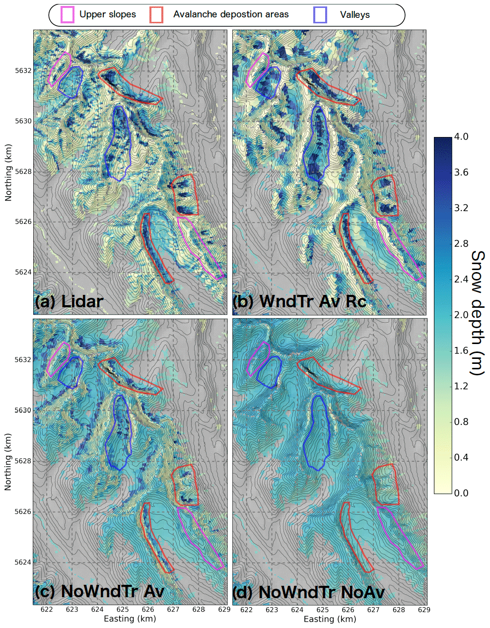
The research builds on the state-of-the-art Canadian Hydrological Model to advance our ability to model snow in mountain environments, which are notoriously tricky places to work. By working on a variable resolution triangular mesh (instead of a regular grid), including redistribution of snow due to both winds and avalanches, and pulling off some difficult wind downscaling, our work generates realistic simulations of snowpack depth compared with airborne LiDAR observations.

\m/

Observed (top left) and modelled snow depths in the Kananaskis study area, Alberta. The full model (top right) includes wind downscaling and accounts for recirculation and gravitational and blowing-snow redistribution. Absent these processes (bottom…

Observed (top left) and modelled snow depths in the Kananaskis study area, Alberta. The full model (top right) includes wind downscaling and accounts for recirculation and gravitational and blowing-snow redistribution. Absent these processes (bottom panels), the model can’t capture the magnitude or complex distribution of observed snow depths.

Two More M.Sc. Proposal Defenses!

Congratulations to both Sara Darychuk and Kevin Ostapowich, who defended their MSc research proposals in June 2020. Sara is working on a data fusion of optical, radar, and LiDAR based observations of snowpacks in the southern Coast Mountains of British Columbia, and Kevin is preparing to head to the Purcell Mountains of BC for an observational study of alpine thermal regimes. Nice work MOSHers!

\m/

MOSH-logo-01.jpg